Last week, my wife, and I, went on a trip to the southwest. She traveled through that area years ago, and would talk about the Pecos River Bridge. I'd been wanting to see it, so off we went.
I've been to the Laredo area. There, and down in the valley. Neither appealed to me, and neither warranted a return visit. Both areas are more of an extension of Mexico, and it doesn't take much clarity of thought to realize white folks are more like an oddity. The Del Rio area was different.
The entire area around Del Rio is in a drought. From the look of the Lake Amistad, it's been that way a long time. A little research showed the lake is being used for Lake Falcon, which is a key resource for agriculture further down the Rio Grande. The water is more important down there, so Lake Amistad is slowly being drained.
The illegal alien problem is obviously a problem A store in Bracketville had a sign stating anyone being dropped off would result in them being reloaded, and sent on. The people there are friendly, and the community is a reminder of times past. The surrounding land is straight from an old Western, and can only be described as near desert. How the ranchers survived in the past is a testament of the tenacious spirit of people. The area around the Hill Country is an oasis in comparison.
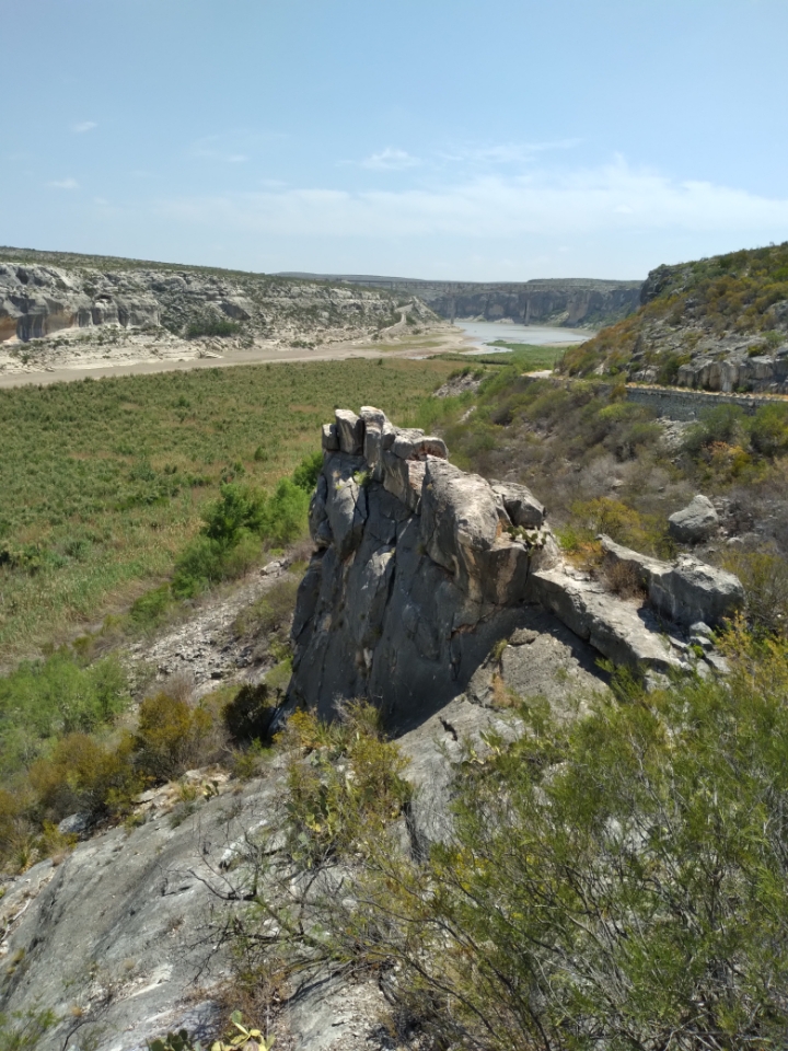
There are no words to describe the grandeur of the Pecos River Gorge. It appears after driving for miles down an almost desolate section of U.S. 90. One second you're driving over rolling hills, and the next second reveals a mind boggling drop-off. The highway bridge that crosses is an engineering marvel, and standing on the observation deck will take your breath away. The Pecos, over millenniums, gouged out the stone to a depth around 300 feet below the surrounding land. The layers of history are obvious on the rock faces, and the surrounding desert receives no benefit from the water.
The pictures don't begin to portray the grandeur, but here are some to view.

That is a beautiful area.
ReplyDeleteJess, using the left side of image 1, what would be what's considered the "usual" or past (normal) water level? Half way up the embankment....3/4? Thanks.
From looking at older photos, I'd guess it would be around five feet deeper. In a flood, I really don't know how much deeper it would be. I do know there is a low water crossing near the park observation area, although it's now closed, as well as the park.
DeleteI did some research on the river. Current level is 1.4 feet. Flood level is 7 feet. In 1978, the highest recorded flood crest was 38.14 feet. Judging by the flood stage, and the current stage, I'd guess the normal level is around four feet, which would cover up much of the vegetation in the river bed. Considering the walls of the gorge are around 300 feet in height, such changes wouldn't be starkly noticeable.
DeleteThanks for the info, Jess. Appreciate it. Like I said, just was curious whether the level in image 1 was high, low or the "usual."
DeleteIt certainly looks like a beautiful area...God's Country!
Did some hiking out that way with my eldest son years ago. Good times. Also, just listened to the BOC song "Del Rio" which I don't think has anything to do with the actual Del Rio.
ReplyDeleteI just drove through Del Rio. Someday, we might make a trip back and stay longer.
DeleteThe api for Del Rio is DRT. And I figured that meant dirt. I used to support our outpost there. I still have a little kid crush on Rosie.
ReplyDeleteFirst time I went out 90 West, I started to get antsy and uncomfortable. I didn't know why, until, like you described, there was this huge gash in the land. I pulled over and just soaked it in. I still don't know why I got nervous before I saw it. Still strikes me as strange.
I really like that area. Out near the Jersey Lilly is some weird twisty cuts in the rock from rushing water. Did you notice those? They look scary as all get out to me. Very narrow, and curvy. I seem to remember them just to the north of the highway out towards Langtry.
That whole run out 90 to Van Horn is just an amazing world. I'd reckon not many other places in Texas have so little AM radio coverage.
I really do miss my time "riding fence" out there. Halcyon days, to be sure. And over before they could be relished. Thanks for the memories.